How GPS fleet tracking works: a guide for fleet managers

GPS fleet tracking is defined as the use of Global Navigation Satellite System (GNSS) signals, onboard vehicle devices, cellular data networks, and cloud software to monitor the real-time location and operational status of commercial vehicles. For fleet managers and logistics professionals, understanding this technology is not optional. It is the foundation of modern fleet management, directly affecting safety, fuel costs, regulatory compliance, and customer service. The global GPS tracking market was valued at $2.5 billion in 2022 and is projected to reach $4.76 billion by 2027. That growth reflects widespread commercial adoption, not a passing trend.
How GPS fleet tracking works: the core technical components
A GPS fleet tracking system is built from four distinct layers: satellites, onboard devices, communication networks, and software platforms. Each layer depends on the one before it. Remove any one, and the system fails.
GNSS satellites and location triangulation
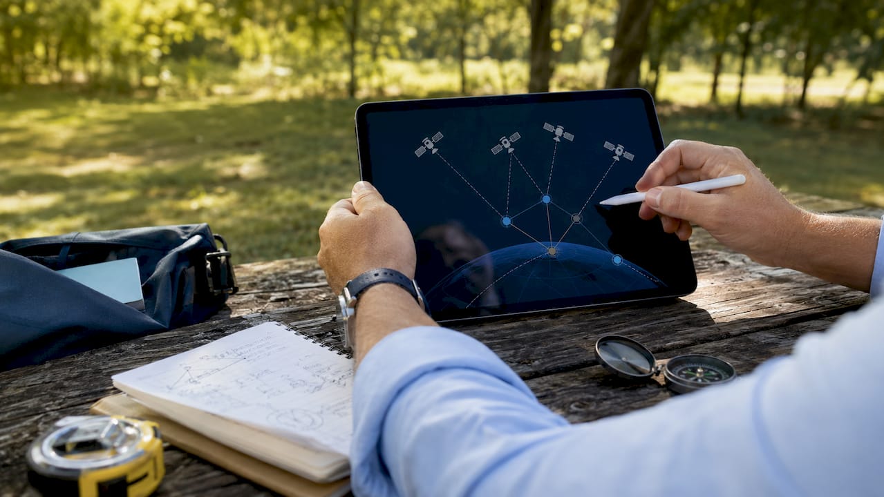
The GNSS constellation, which includes the American GPS system, the Russian GLONASS network, and the European Galileo system, broadcasts continuous timing signals from orbit. An onboard tracking device receives signals from at least four satellites simultaneously and uses the time differences between those signals to calculate its precise position. This process is called trilateration, not triangulation, though the terms are often used interchangeably in the industry. Accuracy typically falls within 2.5 metres under open-sky conditions.
Onboard tracking devices
Two primary device types exist: OBD-II plug-in units and hardwired units. OBD-II plug-in trackers connect directly to the vehicle’s diagnostic port, requiring no specialist tools and taking seconds to install. Hardwired units connect to the vehicle’s CAN bus, giving access to deeper engine data such as coolant temperature, torque output, and fault codes. The choice between them depends on your need for diagnostic depth versus deployment speed.
Key data points captured by onboard devices include:
- Vehicle location (latitude, longitude, altitude)
- Speed and heading (direction of travel)
- Engine status (ignition on/off, idle time, RPM)
- Driver behaviour (harsh braking, rapid acceleration, cornering)
- Fuel consumption (via CAN bus integration)
- Odometer readings (for maintenance scheduling)
Cellular transmission and cloud platforms
Once captured, data travels over 4G or 5G cellular networks to a cloud-based platform. The platform stores, processes, and visualises the data in near real time. Enterprise-grade platforms support simultaneous monitoring of up to 10,000 vehicles, with dashboards displaying location, fuel levels, and driver behaviour in a single interface. That scale makes centralised control of large fleets genuinely practical.
Pro Tip: When evaluating platforms, confirm that the system stores data locally on the device during cellular outages. Urban areas and port zones frequently cause signal interruption, and onboard caching prevents data gaps in your records.
How does GPS tracking data travel from vehicle to fleet manager?
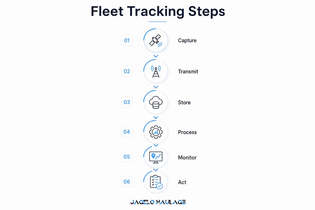
The data flow from vehicle to dashboard follows a defined sequence. Understanding each step helps you identify where failures occur and how to prevent them.
- Capture. The onboard device records location, speed, engine status, and driver behaviour at configurable intervals, typically every 10–60 seconds.
- Local storage. Data is held temporarily in the device’s onboard memory. This protects against cellular outages, particularly relevant in port environments like Felixstowe or Tilbury where signal can be inconsistent.
- Transmission. The device sends data packets over the cellular network to the cloud server. Modern systems use 4G LTE as standard, with 5G adoption increasing for high-frequency data applications.
- Cloud processing. The server receives raw data, applies algorithms to detect events such as speeding or harsh braking, and generates alerts.
- Visualisation. The fleet manager sees live map positions, trip histories, driver scorecards, and maintenance alerts on a web or mobile dashboard.
- Management action. The manager responds: rerouting a vehicle, coaching a driver, or scheduling a service. This response feeds back into operational policy.
The sixth step is the one most fleet managers underestimate. The closed operational loop model holds that GPS data only creates value when it drives a management action that changes behaviour or process. Raw data sitting unreviewed in a dashboard is operationally worthless.
| Data stage | What happens | Manager’s role |
|---|---|---|
| Capture | Device records location and vehicle data | Configure update frequency |
| Transmission | Data sent via cellular to cloud | Confirm coverage in operating zones |
| Processing | Alerts and reports generated | Set thresholds for alerts |
| Visualisation | Dashboard displays live and historical data | Review daily and act on exceptions |
| Action | Driver coaching, rerouting, maintenance | Close the loop to drive improvement |
What types of GPS fleet tracking systems are there?
Fleet tracking systems divide into two fundamental categories: active tracking and passive tracking. The distinction matters because it determines what you can do with the data and when.
Active tracking transmits data in real time over cellular networks. This is the standard for time-sensitive logistics operations, container haulage, and any fleet where live intervention is required. If a driver deviates from a planned route or a vehicle enters an unauthorised zone, an alert fires immediately. Active systems are the correct choice for operations where immediacy and control are non-negotiable.
Passive tracking logs data to onboard memory and uploads it when the vehicle returns to a depot or connects to Wi-Fi. This suits compliance-focused use cases such as tachograph record verification or mileage reporting, where real-time visibility is not required. Passive systems cost less to operate but offer no live intervention capability.
Hybrid systems combine both modes. They transmit key events such as speeding or geofence breaches in real time, while logging full trip data locally for later upload. This reduces data transmission costs while preserving live alert capability.
Beyond the active/passive distinction, multi-constellation GNSS devices that receive both GPS and GLONASS signals deliver materially better accuracy in urban environments. A single-constellation device loses accuracy in city centres where tall buildings block satellite signals. A multi-constellation device maintains position integrity by drawing on a larger pool of satellites. For UK operators running through London, Birmingham, or major port approaches, this is a practical requirement, not a premium feature. You can explore the active vs passive comparison in more detail for container fleet applications.
What are the practical business benefits of GPS fleet tracking?
The business case for GPS fleet tracking rests on four pillars: safety, cost reduction, compliance, and customer service.
Safety improvements
Commercial deployment of GPS fleet tracking reduces accident rates by up to 38% for small businesses. That figure reflects the combined effect of driver behaviour monitoring, real-time alerts, and post-incident coaching. When drivers know their speed, braking, and cornering are recorded, behaviour changes. The monitoring itself acts as a deterrent, and the data provides the evidence base for structured coaching programmes. GPS tracking data also supports fleet insurance risk profiles, which can reduce premium costs for fleets with demonstrable safety records.
Cost reduction
Fuel is typically the largest variable cost in a fleet operation. Route optimisation, idle-time reduction, and speed management all reduce consumption directly. Maintenance scheduling triggered by odometer data and engine fault codes prevents costly breakdowns. Accurate trip records eliminate disputes over mileage claims and overtime.
Regulatory compliance
UK fleet operators must comply with drivers’ hours regulations, vehicle maintenance requirements, and, for certain operations, DVSA roadworthiness standards. GPS systems generate the timestamped records that auditors require. Maintenance alerts triggered by mileage thresholds keep vehicles within service schedules without relying on manual tracking.
Pro Tip: Set geofence alerts around your operating ports. When a vehicle enters or exits Felixstowe, Southampton, or Liverpool, an automatic timestamp is created. That record supports demurrage dispute resolution and provides an auditable arrival log.
Key operational benefits at a glance:
- Reduced fuel costs through idle monitoring and route efficiency
- Lower accident rates and associated insurance costs
- Automated maintenance scheduling from odometer and engine data
- Timestamped compliance records for drivers’ hours and vehicle inspections
- Improved customer service through accurate ETAs and live shipment visibility
How to select and implement a GPS fleet tracking system
Choosing the right system requires matching device type, platform capability, and connectivity to your specific operational context. The wrong choice creates friction without delivering the control you need.
Start with installation method. OBD-II plug-in devices allow rapid deployment across a fleet without taking vehicles off the road. Older hardwired installations required hours of workshop time per vehicle. For fleets of 20 or more vehicles, that difference in deployment time is significant. Hardwired units remain the better choice when you need CAN bus diagnostics or when vehicles lack an accessible OBD-II port.
Platform selection is where most fleet managers make their most consequential decision. Disconnected tracking tools for vehicles, trailers, and assets create data silos that undermine scalability. A unified dashboard that integrates vehicle tracking, trailer monitoring, and asset management into a single interface is the industry standard for operations above a certain scale. Confirm that your chosen platform supports multi-asset tracking before committing.
Key selection criteria:
- Cellular coverage: Confirm 4G coverage across your primary operating routes, including port approaches and rural corridors.
- Data continuity: Verify that the device caches data locally during outages and uploads automatically on reconnection.
- Integration: Check compatibility with your existing transport management system (TMS) or maintenance software.
- Scalability: Confirm the platform handles your projected fleet size without performance degradation.
Staff acceptance deserves direct attention. Early concerns about GPS surveillance have largely been resolved as the industry shifted its framing from monitoring to coaching and safety. Present the system to drivers as a tool that protects them in the event of a false claim or road incident. That framing is accurate and it accelerates adoption. For broader operational context, the logistics fleet management guide covers integration of tracking technology into wider fleet workflows.
Key takeaways
GPS fleet tracking delivers operational value only when satellite data, cellular transmission, cloud processing, and management action work as a connected system.
| Point | Details |
|---|---|
| Four-layer architecture | Satellites, onboard devices, cellular networks, and cloud software must all function together. |
| Active vs passive choice | Active tracking suits real-time logistics; passive suits compliance-only record-keeping. |
| Multi-GNSS accuracy | Devices using both GPS and GLONASS maintain accuracy in urban areas and port approaches. |
| Closed operational loop | GPS data creates value only when it drives a management action that changes behaviour or process. |
| Unified platform | Consolidate vehicle, trailer, and asset tracking into one dashboard to avoid data silos. |
What GPS fleet tracking has taught me about running a tighter operation
The technology has changed more in the past five years than in the previous fifteen. When I first worked with fleet tracking systems, the primary use case was simple: know where your vehicles are. That was genuinely useful, but it was also the limit of what the systems could deliver reliably.
What I find more interesting now is the shift from location awareness to operational intelligence. The data coming off a modern telematics device, including engine load, braking patterns, idle time, and fuel draw, tells you more about how a vehicle is being operated than any driver debrief ever could. The managers who extract real value from this are the ones who build structured review processes around the data, not the ones who simply install the hardware and assume the system will manage itself.
The pitfall I see most often is fragmentation. A fleet runs one tool for vehicle tracking, a separate system for trailer monitoring, and a spreadsheet for maintenance. None of these talk to each other. The result is that the data exists but the insight does not. Consolidating onto a single platform is the single most impactful change most mid-sized fleets can make, and it is consistently underestimated.
On staff culture: the surveillance framing is largely a legacy concern at this point. Drivers who understand that the system protects them in a disputed incident, or flags a mechanical fault before it becomes a breakdown, tend to accept it readily. Leadership sets the tone here. If you introduce GPS tracking as a monitoring tool, you will get resistance. If you introduce it as a safety and support system, you will get buy-in.
— Vytautas
GPS tracking in container haulage: how Jhaulage puts it to work
Container haulage demands a level of operational precision that general freight does not. Port slot times, demurrage windows, and multi-leg intermodal movements leave no margin for uncertainty about vehicle location or status.
Jhaulage operates a fleet of over 40 trucks and trailers across major UK ports including Felixstowe, Tilbury, Southampton, and Liverpool, with GPS tracking fitted as standard across the entire fleet. That means real-time visibility for every container movement, automated arrival timestamps for port compliance, and live ETAs for customers who need to plan their own receiving operations. If you need a container haulage partner whose fleet tracking capability matches the precision your supply chain requires, Jhaulage is ready to discuss your requirements.
FAQ
What is GPS fleet tracking?
GPS fleet tracking is a system that uses GNSS satellites, onboard vehicle devices, cellular networks, and cloud software to monitor the real-time location and operational data of commercial vehicles.
How accurate is GPS fleet tracking?
Under open-sky conditions, modern GNSS devices achieve accuracy within 2.5 metres. Multi-constellation devices using both GPS and GLONASS maintain higher accuracy in urban areas where building interference degrades single-constellation performance.
What is the difference between active and passive GPS tracking?
Active tracking transmits data in real time over cellular networks, enabling live intervention. Passive tracking logs data locally and uploads it later, making it suitable for compliance record-keeping rather than operational control.
Can GPS tracking reduce fleet operating costs?
GPS tracking reduces costs through fuel savings from route and idle-time management, lower accident rates, and maintenance scheduling that prevents costly unplanned breakdowns. Commercial deployments report accident reductions of up to 38%, which directly affects insurance and liability costs.
How long does it take to install a GPS tracker on a fleet vehicle?
OBD-II plug-in trackers install in seconds without specialist tools. Hardwired units require workshop time but provide access to deeper CAN bus diagnostics, including engine fault codes and fuel consumption data.