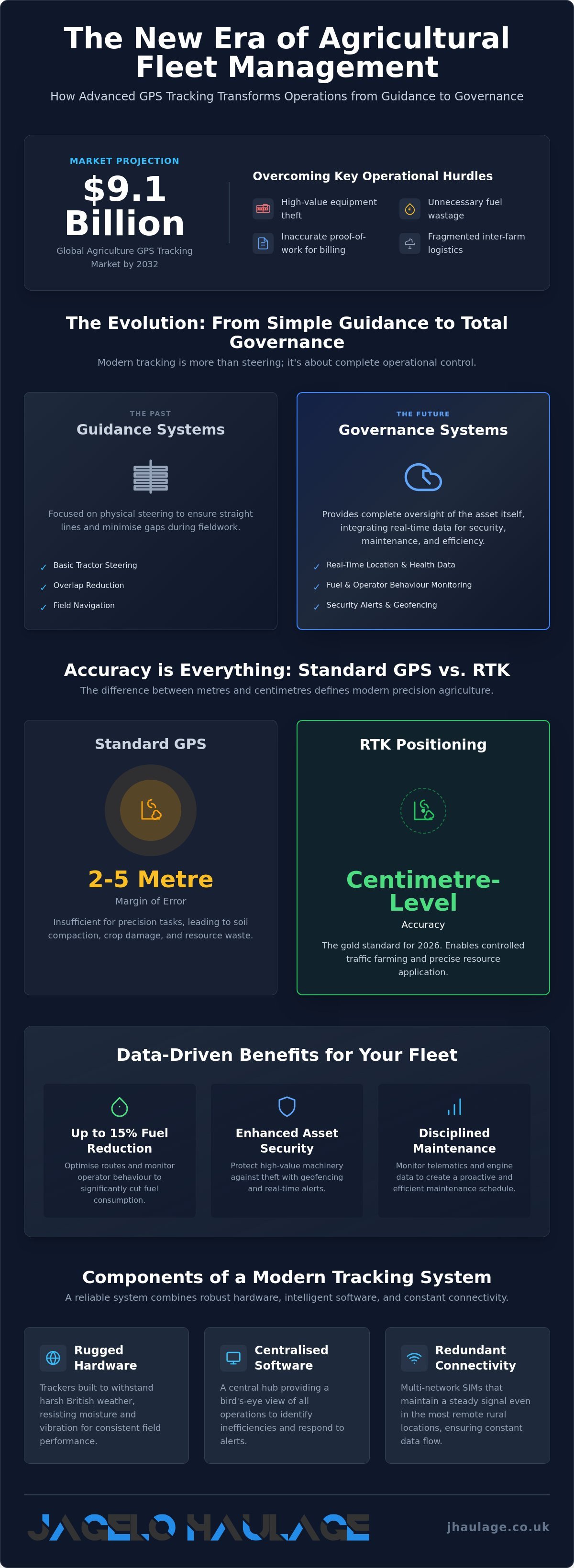
With the global agriculture gps tracking market projected to reach USD 9.1 billion by 2032, the transition from basic navigation to integrated fleet management is now a commercial necessity. You likely recognise the persistent threat of equipment theft in rural areas and the difficulty of providing precise proof-of-work for client billing. These operational hurdles often result in unnecessary fuel waste and fragmented logistics when you move machinery between disparate farm blocks. Relying on outdated methods compromises the security of your assets and the reliability of your service delivery.
This article demonstrates how advanced agriculture gps tracking serves as a strategic anchor for your entire operation. You will discover how precision systems reduce fuel consumption by up to 15% and provide the robust security required for high-value machinery. We examine the integration of location data into broader management platforms to ensure your assets remain protected and your transport schedules stay efficient. By prioritising functional reliability, you can transform your machinery into a disciplined, data-driven fleet that supports long-term operational stability.
Key Takeaways
- Understand how RTK positioning provides the centimetre-level accuracy required to transition precision field work from a logistical luxury to a necessity.
- Protect high-value assets against organised rural crime by implementing Agriculture gps tracking as a primary deterrent and recovery tool.
- Monitor telematics data, including fuel levels and operator behaviour, to reduce waste and maintain a disciplined maintenance schedule for your fleet.
- Optimise your supply chain by coordinating with haulage partners who utilise modern fleets and advanced tracking for secure container deliveries from UK ports.
- Transition to data-driven operational workflows to provide accurate proof-of-work for billing and to organise transport based on real-time machine availability.
Understanding the Role of Agriculture GPS Tracking in 2026
Agriculture gps tracking has evolved into a comprehensive system of global navigation satellite systems (GNSS) designed to monitor, guide, and protect agricultural assets. In 2026, this technology is no longer an optional enhancement for large-scale operations; it is a fundamental requirement for maintaining commercial viability. UK farmers face rising operational costs and complex logistics, making the transition to Precision agriculture a logistical necessity. This movement allows for site-specific management that improves resource use whilst ensuring that every movement of machinery is accounted for and secured.
The distinction between guidance-based GPS and telematics-based GPS is critical for modern asset management. Guidance systems focus on the physical steering of the tractor to ensure straight lines and minimal gaps. In contrast, telematics-based Agriculture gps tracking focuses on the governance of the asset itself. It provides real-time data on engine health, fuel levels, and precise location. This level of oversight allows for the seamless organisation of complex rural tasks, such as moving high-value machinery between disparate farm blocks or coordinating with professional haulage partners like Jagelo Haulage for secure container deliveries.
From Guidance to Governance: The Evolution of Farm Tech
The 2026 technological landscape integrates satellite data with local IoT sensors to create a unified operational picture. This integration is essential for reducing overlap during field operations. Precision guidance can save between 10% and 15% on fuel costs, directly impacting the bottom line. Modern governance now extends beyond the tractor. It includes the tracking of implements, trailers, and shipping containers. This ensures that every component of the agricultural supply chain remains visible and protected during transit.
Key Components of a Modern Agricultural Tracking System
A reliable system requires hardware capable of withstanding the harsh British weather. Ruggedized trackers are built to resist moisture and vibration, ensuring consistent performance in the field. The software component acts as a centralised hub, providing a bird's-eye view of nationwide operations. This allows managers to identify inefficiencies and respond to security alerts immediately. Connectivity remains a challenge in remote rural locations, so systems now utilise multi-network SIMs to maintain a signal amongst the most isolated blocks. This redundant connectivity ensures that data flow remains steady and predictable, which is vital for maintaining the security chain.
The Technical Mechanics of Precision Agriculture and Telematics
Technical precision serves as the backbone of modern farm efficiency. Whilst standard systems provide general location data, advanced Agriculture gps tracking relies on specific mechanical protocols to deliver measurable operational value. Selecting the right hardware requires expert guidance on selecting agricultural GPS systems to ensure the technology integrates with your existing machinery fleet. This integration ensures that every litre of fuel and every hour of labour is utilised with maximum discipline.
RTK vs. Standard GPS: Accuracy Levels Explained
Standard GPS often permits a margin of error between two and five metres. This variance is insufficient for controlled traffic farming where centimetre-level accuracy is required to prevent soil compaction and crop damage. Real-Time Kinematic (RTK) positioning corrects these errors by using a fixed local base station or a network of NTRIP casters to provide constant, real-time corrections to the machinery. This infrastructure creates a stable reference point that eliminates the 'drift' associated with standard satellite signals. RTK accuracy represents the gold standard for 2026 agricultural logistics and precision field operations.
Data integration transforms simple coordinates into strategic assets. Geographic Information Systems (GIS) allow you to layer GPS data over soil and crop maps, creating a precise record of field health and yield performance. This allows for variable-rate applications that target specific zones with precision. Beyond agronomy, 'Geofencing' establishes virtual boundaries around your farm blocks or storage yards. If a machine exits these designated zones without authorisation, the system triggers an immediate alert to your mobile device or central hub. It provides a critical layer of protection for high-value assets and ensures that unauthorised usage is detected instantly.
Telematics: The 'Black Box' of Your Agricultural Fleet
Telematics systems act as a comprehensive diagnostic tool for your machinery, functioning much like an aircraft's black box. They monitor specific operational metrics, including:
- Engine idling time to identify fuel waste.
- Operator behaviour to ensure safe and efficient machine handling.
- Real-time fuel consumption rates.
- Hydraulic pressure and temperature alerts.
Remote diagnostics allow you to predict maintenance needs based on actual engine hours and load factors before a failure disrupts your harvest schedule. For contractors, this 'Proof of Work' data provides an indisputable, timestamped record for billing external clients. It removes ambiguity from the billing process and guarantees that you're compensated for the exact work performed. If you require professional support to move these high-value, tracked assets between locations, you can request a transport consultation to secure your logistics chain.
Enhancing Security and Asset Protection with Advanced Tracking
Organised rural crime remains a significant operational risk for the UK agricultural sector. High-value machinery, such as combine harvesters and specialist tractors, is frequently targeted by sophisticated criminal groups due to its high resale value and portability. Implementing Agriculture gps tracking provides a robust layer of protection that serves as both a primary deterrent and a critical recovery tool. Professional tracking systems shift the security focus from reactive measures to proactive governance, ensuring your assets remain under constant oversight.
Geofencing as a Digital Perimeter
Geofencing allows you to establish virtual boundaries around farmyards, specific fields, and predetermined transport routes. The moment an asset crosses these boundaries without authorisation, the system triggers an instant alert to your mobile device or central hub. This technology is particularly effective when integrated with transport schedules for inland container haulage. It ensures assets remain on their designated route whilst being moved from ports to farm blocks. By maintaining end-to-end visibility during the transit phase, you eliminate the security gaps often found in third-party logistics. Digital perimeters provide the reassurance that your equipment is exactly where it's scheduled to be.
Theft Recovery and Law Enforcement Collaboration
If a theft occurs, real-time location data is vital for a successful recovery operation. You can provide law enforcement with precise coordinates, increasing the likelihood of intercepting the stolen asset before it's dismantled or exported. Many operators now utilise secondary 'stealth' trackers amongst their most valuable machinery. These battery-backed devices are hidden deep within the machine's chassis, remaining dormant until activated. This prevents criminals from easily disabling the primary tracking unit. Whilst being 'fully insured' provides financial cover, active Agriculture gps tracking ensures operational continuity by preventing the long-term loss of essential equipment.
Advanced systems often include engine immobilisation features. You can remotely disable a machine's engine if it exits a geofence during unscheduled hours. This prevents the asset from being driven onto a trailer or away from the site. Beyond immediate security, professional tracking can lead to lower insurance premiums. Insurers recognise the reduced risk associated with active monitoring and documented recovery protocols. By investing in these systems, you project the image of a disciplined partner that prioritises the safety and efficiency of every operation.
Best Practices for Integrating GPS Data into Operational Workflows
Successfully implementing Agriculture gps tracking requires a shift from simple navigation to comprehensive asset intelligence. You must transition from reactive management to a disciplined, data-driven workflow that prioritises operational reach and performance. This approach ensures that every piece of equipment is used to its full potential whilst maintaining the strict protocols required for a modern supply chain. By centring your operations around real-time data, you can reorganise your logistics to meet the high stakes of the 2026 agricultural season.
Data Management and Privacy
Managing large-scale location data necessitates a firm commitment to GDPR compliance, especially when monitoring operator behaviour and precise movements. You should prioritise cloud-based platforms that facilitate multi-user access across different sites. This allows managers and operators to view real-time machine availability simultaneously, ensuring that everyone follows the same operational route. Advanced data encryption protocols ensure that sensitive agricultural trade secrets and field maps remain protected from external breaches in 2026. Training your staff to utilise these interfaces effectively ensures that field navigation remains precise and that every operator understands the importance of data accuracy for billing and reporting.
Optimising Transport Logistics
Efficiency in logistics is achieved by reducing 'empty running', which refers to the movement of vehicles without a payload. By coordinating your machinery moves with a professional container transport fleet, you can ensure that transport resources are utilised on both legs of a journey. Analysing historic route playback serves as a strategic tool for operational review. It allows you to audit the movements of your fleet over several months to pinpoint bottlenecks in your transport routes. If certain paths consistently lead to delays or excessive idling, you can reorganise your transport paths to save time and fuel.
This synergy between farm-level tracking and professional port logistics services UK provides the end-to-end visibility required for nationwide operations. You can provide your customers with accurate ETAs based on real-time data, which builds long-term trust and reinforces your reputation for reliability. This methodical approach to improvement mirrors the industrial discipline found in port-side operations, where every minute of transit time is calculated for maximum efficiency. To see how a professionally tracked fleet can support your logistics, you can request a bespoke haulage quote to secure your next machinery move.
Why Professional Haulage Partners Prioritise GPS-Monitored Logistics
Professional haulage partners act as the final link in a secure agricultural supply chain. Whilst on-farm Agriculture gps tracking secures machinery during field operations, professional logistics ensures that these assets remain protected during the high-risk transit phase between UK ports and farm blocks. Jagelo Haulage positions itself as a strategic partner by maintaining end-to-end visibility through a modern fleet of over 40 trucks. This disciplined approach to monitoring guarantees that high-value cargo is never outside of a controlled environment.
Choosing a corporate entity with 15 years of industry experience provides a level of security that unmonitored providers cannot match. Every movement is logged; every route is optimised. This level of oversight is essential for moving specialist machinery or containers that represent significant capital investment. You gain the reassurance that your assets are handled by a master of the fundamentals who understands the high stakes of agricultural timelines. We prioritise the safety and efficiency of your operations above all else, ensuring a brand atmosphere of functional reliability.
The Jagelo Haulage Standard: Punctuality and Protection
Our commitment to operational reliability is rooted in the use of industry-leading telematics for every delivery. We utilise advanced tracking to avoid delays and ensure that every delivery follows a strictly managed protocol. This technology allows us to provide the quiet confidence that comes from a seasoned professional. By integrating our own fleet data with your operational requirements, we eliminate the ambiguity often found in rural transport. Our drivers follow precise routes, whilst our central hub monitors for any deviations that might compromise the security of the cargo.
Securing the Future of Agricultural Transport
Merchant haulage solutions must now include robust GPS oversight to meet the demands of modern Agriculture gps tracking standards. Real-time fleet visibility enables a level of same-day responsiveness that is critical during harvest or planting seasons. This visibility allows us to reorganise routes instantly if road conditions change, ensuring that your machinery arrives exactly when needed. Professional logistics is not merely a physical action; it is a strategic outcome that protects your operational continuity and maintains the integrity of your supply chain.
The movement of agricultural goods requires a partner that understands the industrial nature of the sector. We provide the protected outcomes you require to keep your farm blocks productive and your equipment secure. Our steady, predictable communication rhythm mirrors the reliability of our physical operations. Ready to secure your agricultural logistics? Contact Jagelo Haulage for reliable container transport to ensure your assets are moved with the highest level of professional discipline.
Securing Operational Stability Through Technical Precision
Adopting advanced technical standards is the most effective way to protect your machinery from rural crime whilst improving field efficiency. Centimetre-level RTK accuracy and robust geofencing allow you to transition from simple navigation to comprehensive asset governance. These tools ensure that every movement is intentional and every operational cost is monitored. By prioritising functional reliability, you can transform your machinery into a disciplined, data-driven fleet that supports long-term commercial viability.
Strategic success in the 2026 season requires a logistics partner that understands the high stakes of the supply chain. Professional Agriculture gps tracking remains most effective when complemented by secure, monitored transport. Jagelo Haulage leverages 15 years of UK port logistics expertise and a modern fleet of over 40 trucks to provide the end-to-end visibility your operations require. Our professionally managed transport operations ensure your high-value assets remain protected from port to farm gate. You can secure your agricultural logistics with Jagelo Haulage’s tracked fleet to guarantee the safety and efficiency of your next move. Establishing these protocols today ensures a more resilient operation for the future.
Frequently Asked Questions
What is the difference between GPS and telematics in agriculture?
GPS provides precise geographical coordinates, whilst telematics integrates that location data with mechanical diagnostics. Telematics systems monitor engine load, fuel consumption, and hydraulic temperatures to provide a comprehensive overview of machine health. This allows you to manage the governance of the asset rather than just its position. It transforms a simple tracker into a strategic management tool for your entire machinery fleet.
Can GPS tracking help reduce fuel consumption on my farm?
Yes, Agriculture gps tracking reduces fuel waste by eliminating field overlaps and monitoring engine idling times. Precision guidance systems can save between 10% and 15% on fuel costs by ensuring tractors follow the most efficient path. By identifying machines that idle excessively in the yard or field, you can implement more disciplined operational protocols to reduce unnecessary consumption.
How much does it cost to install a GPS tracking system on a tractor?
Installation costs for tracking hardware typically range from £60 to £240 per vehicle for professional labour. Hardware prices vary significantly based on accuracy requirements; simple theft-prevention trackers are relatively inexpensive, whilst centimetre-accurate RTK systems involve a higher capital investment. You should also account for monthly subscription fees which cover the data transmission and software hosting required for real-time monitoring.
Is agriculture GPS tracking effective against professional thieves?
Professional tracking is a highly effective deterrent because it combines geofencing with secondary 'stealth' units. If a thief attempts to move a machine outside of its designated zone, the system triggers an immediate alert and can immobilise the engine. Hidden, battery-backed trackers remain dormant until needed, making them difficult for professional thieves to locate and disable during a recovery operation.
Do I need a subscription for agriculture GPS tracking services?
Most professional systems require a subscription to cover the costs of cellular data and cloud-based software access. These fees ensure that your tracking data is transmitted securely and stored in a centralised hub for historical review. Subscriptions also provide the necessary infrastructure for real-time alerts and remote diagnostics, which are essential for maintaining the security and efficiency of a nationwide agricultural operation.
Can I track my agricultural containers during port-to-farm transport?
You can track agricultural containers during transit by partnering with a professional haulage firm that utilises an integrated fleet. Jagelo Haulage operates a modern fleet of over 40 trucks equipped with advanced tracking to ensure end-to-end visibility from UK ports to your farm gate. This allows you to monitor the security of your cargo and receive accurate ETAs throughout the delivery process.
How does GPS tracking improve 'Proof of Work' for contractors?
GPS tracking provides an indisputable, timestamped record of exactly where and when a machine was operational. Contractors use this 'Proof of Work' data to generate accurate invoices based on precise field coverage rather than estimated hours. It removes ambiguity from the billing process and provides clients with the transparency required to build long-term trust and professional reliability.
What happens to the GPS signal in remote areas with poor mobile coverage?
Modern systems maintain connectivity in remote areas by using multi-network SIMs that switch between available providers. If a total signal loss occurs, the hardware stores the data on internal memory and uploads the logs the moment a connection is restored. This ensures that your 'Proof of Work' records and historical route playback remain complete, even amongst the most isolated rural blocks.